J.J. slips Willie Nelson's "On the Road Again" into the system and eases his way down the road away from Copper Canyon Princess Wilderness Lodge. I say eases because that's how the coach moves down the steep, serpentine road. No wonder this place will be closed for the winter in just a week or two.
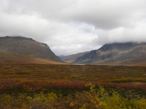
The ride to Valdez winds through the Chugash Mountains. Because of their proximity to the
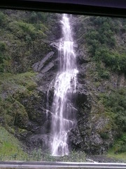
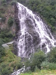
 coast, the the Chugash Mountain Crest is the snowiest place in the world with an average annual snowfall of over 600 inches. We travel the Richardson Highway built in the mid 1940s. Prior to that time, the way to move from the coast inland was over the “Goat Trail” which wound through the mountains. Today what is left of that wilderness trail can be be recreationally hiked. It's another world since the 1940s. Hikers can pick up the Goat Trail off the highway at Bridal and Horsetail Falls.
J.J quickly points out Mt. Billy Mitchell (named after Billy Mitchell, father of the modern Air Force and the man who correctly felt that control of the North American continent would be done by those who held Alaska, a point proven during WWII).
The ride to Valdez winds through the Chugash Mountains. Because of their proximity to the
 coast, the the Chugash Mountain Crest is the snowiest place in the world with an average annual snowfall of over 600 inches. We travel the Richardson Highway built in the mid 1940s. Prior to that time, the way to move from the coast inland was over the “Goat Trail” which wound through the mountains. Today what is left of that wilderness trail can be be recreationally hiked. It's another world since the 1940s. Hikers can pick up the Goat Trail off the highway at Bridal and Horsetail Falls.
J.J quickly points out Mt. Billy Mitchell (named after Billy Mitchell, father of the modern Air Force and the man who correctly felt that control of the North American continent would be done by those who held Alaska, a point proven during WWII).

We also pass the beautiful Worthington Glacier and once again see Nature's palette at work.

One marvel follows another, and coming over the Thompson Pass, rising up through the clouds and coming down through the clouds is breathtaking. Thompson Pass rises to 2,678 feet and can get as much of 980 inches of snow. Those poles are not mere light poles. They indicate to the snow plowers the depth of the snow and also show them the road. Imagine the snow like that! This is not a road one wants to slip off!
 I'd bet that through most of the lower 48, a sign reading Easy Freeze means ice cream. Not in Alaska! Nothing like Flash Freezing FISH!!!! Ha Ha Ha
  It is a bit sad to get to Valdez. It's the end of the land part of our tour. Though it's been spectacular, we also know we've barely scratched the Alaskan surface. In fact, we've been advised that when we return, we should make sure to get to Nome. It's an entirely different world.
Valdez is very small, and in the mountains across the water we see the huge oil tanks.  Valdez is 96% recovered from the 1989 Exxon Valdez Oil Spill. We've no time to explore, however, as we board our catamaran for the speedy trip down the Prince William Sound to Whittier where we'll meet the Coral Princess.
  Our catamaran is quite a boat. It has real-time sonar and map, and it's fascinating to follow our progress, to observe icebergs, perhaps results of Columbia Glacier's calving, and spot those seals resting on a buoy.
  We see fishing boats on the Sound. Silver salmon are starting to run. Fishermen cast their gill nets and bring their catch to the tenders that bring the fish back to port.

Valdez is 96% recovered from the 1989 Exxon Valdez Oil Spill. We've no time to explore, however, as we board our catamaran for the speedy trip down the Prince William Sound to Whittier where we'll meet the Coral Princess. Our catamaran is quite a boat. It has real-time sonar and map, and it's fascinating to follow our progress, to observe icebergs, perhaps results of Columbia Glacier's calving, and spot those seals resting on a buoy. We see fishing boats on the Sound. Silver salmon are starting to run. Fishermen cast their gill nets and bring their catch to the tenders that bring the fish back to port.(NOTICE THE SIZE OF THE BOAT COMPARED TO THE "LITTLE" ICEBERGS)
It's a difficult but very important way of life they lead. This life was violently interrupted in 1964 by the Good Friday Earthquake. Valdez was the city closest to the epicenter, and the earth rose and fell about three feet. Prince William Sound emptied and came back as tsunamis that virtually destroyed Valdez and left 32 people dead. It is one more place that proves Alaska is not an easy place.
Technorati Tags:
travel, trips, vacations, travel blogs, Third Age Traveler, photography, travel photos, images, United States, Alaska, Valdez, Prince William Sound, Exxon Valdez, Thompson Pass, Bridal Falls, Horseshoe Falls, snow, nature, mountains, roads, Mt. Billy Mitchell, glaciers, ice, Worthington Glacier, animals, water, seals, catamarans, boats, Princess, cruises

 Dave gives us a wonderful tour of the area. We move, once again, to another world. The watercolor landscapes of Denali and the shrubs and bushes along the Denali Highway give way to spruces, aspens, and other taller, thin trees. There are ten species of trees in this area of the state among which are black and white spruce, cottonwood aspen, birch, balsam, and poplar. A temperature of forty below zero is the cutoff for growing even though the area does get about ten inches of rain yearly. Only the hardiest varieties grow here. Trees grow slowly. While they may appear young by their sizes, many are quite old.
 We travel in a mini-van, and with Dave we are able to get up close to the Alaska Pipeline. Rob and I know people who came up here to work on the pipeline.
  The best part of our time with Dave is spent on the two trails we walk. He shows us different ecological systems and explains how they work. We see the important work of beavers, learn about permafrost and come to understand the lack of variety in tree species. The trails we follow help us solve that age old question, Does a bear…..
 We walk along ridges overlooking the Copper River Valley where once again we are treated to jaw-dropping views.
  In a tent reminiscent of our Girl Scout platform tents, Dave has a trail-side museum with artifacts illustrating the many things we’d learned during our time with him.
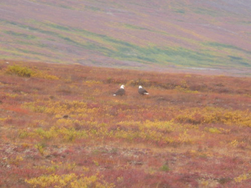
 Some kits show us the skulls of animals in the area, and he has skins, donated, which are fun to touch and in the case of a grizzly bear, to try on. He emphasizes, as did our guide in Denali, the inter-relationships that exist in nature. Right now, for instance, the snowshoe hare population is declining. They are food for the lynx. What will happen to the lynx? The Denali guide indicated that this is cyclical and that nature adjusts. The hare will return and then the lynx will too.
  Amazing to me is Dave’s presentation of the mandible of a moose. (not the above photo) It is so heavy I cannot pick it up with one hand. He explains how in nature every part of an animal is utilized. The rodents, for instance, eat the moose antlers as a source of calcium.

 We also get to see a food cache up close. Remember that the legs of these caches are greased up to prevent climbing animals from getting in.
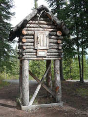


 I add for the sake of fairness, the state of Alaska cannot pave this road because the heaving atop the permafrost makes it impossible. Truly this is another world. So with booklet in hand, a hopefully carefully maintained coach from Princess, and faith in our driver and excellent tour narrator, J.J., we embark. J.J. has us play a game. We will count every vehicle we see on this journey. I’ll tell you the number at the end of this post.
 Our heavy coach crosses the Susitna River driving over a 1.326 foot wooden bridge made of black spruce.
  At some points we drive over
  We stop for lunch in the


 We dine on a hearty chili, a delicious soup, a thick, dense bread (all the bread up here is thick and dense; I guess it’s left over from the hearty sourdough breads). Our cutlery is plastic and our dinnerware courtesy of "Solo." It's fine with us and it somehow fits with the warm, homey atmosphere that is the McClaren Lodge. I imagine how wonderful this must be for some snowmachiner or dog musher, the only passerbys in the winter, here on a dark, snowy night becoming part of the family, sharing the stew and watching one of the dvds. Then he'd delight as we did in a nice slice of McClaren berry pie, a combo of strawberry, rhubarb, apples, raspberry and blackberry. Pretty darned good!
 The Denali Highway ends at Paxton, a town founded in 1906 and now boasting a population of 43. We make a pit/snack stop in the Paxton lodge before heading down the Richardson Highway to our destination, the Copper River Princess Lodge.
